Let’s start this post -Map of Jharkhand with districts name
- INTRODUCTION
State Jharkhand, there are five divisions, twenty-four districts, forty-three subdivisions,264 blocks,228 cities & 32620 village.
At present chief minister – Hemant Soren
Governer- Dropati Murmu
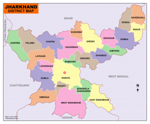
Name of districts (जिला )-24
1. Garhwa
2.Latehar
3. Palamu
4.Chatra
5. Simdega
6. Lohardaga
7. Ranchi (capital)राजधानी
8. Gumla
9. Khuti
10.East Singhbhum (Jamshedpur)
11. West Singhbhum (Chaibasa ) ( Singhbhum means land of the lion )
12. Seraikela -Kharsawan
13. Ramgarh
14. Bokaro
15. Hazaribagh
16. Koderma
7. Giridih
18. Dhanbad
19. Deoghar
20. Jamtara
21. Dumka
22. Pakur
23. Godda
24. Sahebganj
Division (प्रमंडल )- 5
1. North Chhota Nagpur division( उत्तरी छोटानागपुर )-7 (Headquarter-Hazaribag)
- Hazaribagh
- Ramgarh
- Koderma
- Chatra
- Dhanbad
- Bokaro
- Giridih
2.South Chhota Nagpur division (दक्षिणी छोटानागपुर )-5 (Headquarter- Ranchi)
- Ranchi (रांची जिला का पूर्व का नाम लोहरदगा था,जिसे 18 99 में रांची दिया गया )
- Khuti
- Gumla
- Simdega
- Lohardaga
3. Kolhan division (कोल्हान ) -3(Headquarter-Chaibasa)
- East Singhbhum
- West Singhbhum
- Seraikela-Kharsawan
4. Palamu division -( पलामू )3 (Headquarter-Medininagar)
- Palamu
- Latehar
- Garhwa
5. Santhal Parganas division – (संथाल )6 (Head quarter-Dumka )
- Deoghar
- Dumka
- Jamtara
- Godda
- Pakur
- Saheb ganj
DIRECTION OF JHARKHAND –
North – Bihar
South- Odisha
East – West Bengal (पश्चिम बंगाल )
West–Uttar Pradesh, Chhattisgarh.
Jharkhand population -3,29,88134 (2.72 % of India )
Male-1,69,30315
Female-1,60,57819
Birth rate( वर्द्धि दर) -22.34 (2001-2011)
Average rate -2011- 949
Population density -2011- 414
Literacy rate-66.41%
Male literacy-76.84%
Female literacy-56.21%
Top literacy rate – Ranchi (76%) according to 2011
Less literacy rate -Pakur
Lodh waterfall -It is the highest waterfall in Jharkhand and the 21st waterfall in India.
height –143 meters / 469 feet.located in the Burha river in Latehar. (also known as Budha waterfall)
Hundru waterfall-It is 2nd the highest fall in Jharkhand and the 34th waterfall in India.
height –98metres/322feet. located in the Swarn Rekha river in Ranchi.
- Rajrappa is a famous temple of Maa Chhinmastikka, it is 51st Sakti pith in India. located at Gola in Ramgarh district.
- Dewri temple is a famous temple of Maa Durga 16 hand, it is located tata – Ranchi highway(NH33),60 km away from Ranchi. The main attraction is 700 years old idol.
I hope guys you like this post -Map of Jharkhand with districts name.